- The Digital Archives Top
- Picture Map of the Shimbashi-Yokohama Railroad
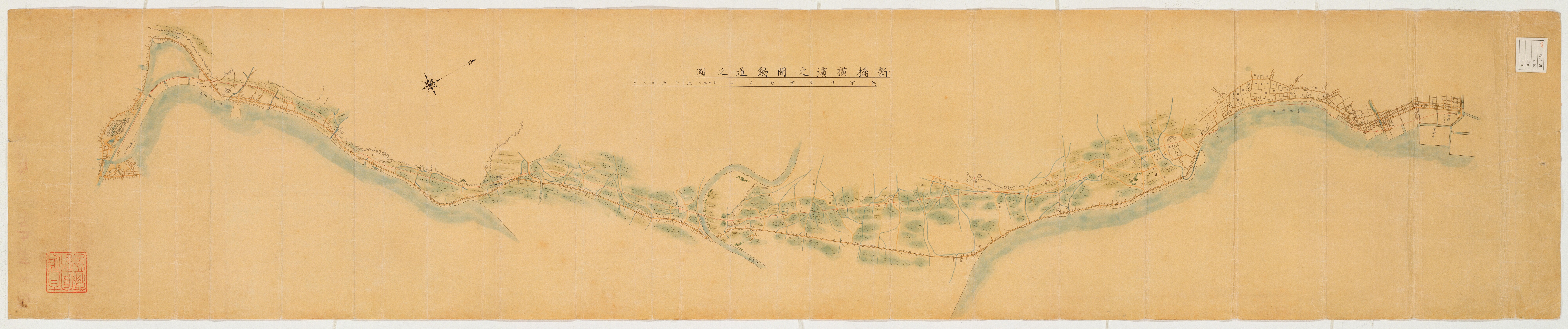
Picture Map of the Shimbashi-Yokohama Railroad
The railway networks have been developed since the temporary opening of Shinagawa-Yokohama line May in the 5th year of Meiji (1872), which have deeply related to the development of industry.
This is a railroad map from Shimbashi to Yokohama.It can be assumed that the map was prepared in the occasion of the inauguration of the first railway in Japan in the 5th year of Meiji (1872).The first railway opening in Japan was temporarily opening between Shinagawa and Yokohama (present Sakuragi-cho) on May 7 in the 5th year of Meiji (1872).Rails between Shimbashi and Shinagawa, where the construction was delayed, were completed to lay down on July 25 of the same year.
The railway between Shimbashi and Yokohama was officially opened on September 12.Distance between the two stations was 29 km at the time and time required was 53 minutes without stopping. This drawing covers the railway between Shimbashi and Yokohama. Agency prepared this drawing and the date of production are both unknown.
It is believed that the Ministry of Construction, the administrative office for the railway prepared before or after the opening and submitted to the Grand Council of State (Dajokan).
"Kobun Fuzoku no Zu (pictures and charts affiliated with Kobun Roku)" in which this map is included, together with "Kobun Roku (Compiled Records of the Grand Council of State )" were designated as National Important Cultural Properties in the 10th year of Heisei( 1998).
Original sizes: 193.2 cm from east to west and 38.6 cm from north to south.
二次利用について:
ただし、画像については「画像等データの二次利用について」をご確認ください。