- The Digital Archives Top
- Contents
Contents
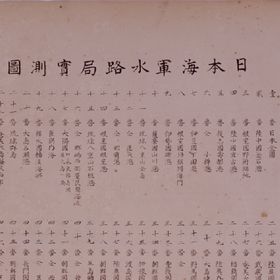
A collection of copperplate marine charts made in the early Meiji period. The Meiji government instituted the Hydrographic Section of the Navy Division of the Department of Military Affairs in the Tsukiji district of Tokyo in the 4th year of Meiji( 1871). In 1872, survey by Japanese themselves, in the port of Kamaishi in Rikuchu Province (present-day Miyagi Prefecture). Yanagi Narayoshi (1832 - 1891), hailed from the Tu clan, and was appointed to serve as the first director of the Hydrographic Department, which was established in a reorganization of the administrative setup in the 19th year of Meiji(1886). In one corner of the charts are noted items including position (latitude and longitude), tidal range, and the names of the survey team members. The collection contains charts that were made in the years up to and including 1878.Owing to differences of size, a single page contains more than one chart in some cases. In the original collection, a single page measures 53 cm by 69 cm, and a two-page spread, 106 cm by 69 cm. The thirtieth entry in the table of contents (Oshima Kamise Supplementary Chart) is contained on the same page as the ninth entry (Sazara Harbor, Ise Province). In some cases, the actual order in the binding is different from that in the table of contents.
ただし、画像については「画像等データの二次利用について」をご確認ください。


